First Drill Hole Confirms High-Grade Copper Skarn Mineralization at the Birch Project
VANCOUVER, British Columbia, Oct. 15, 2025 (GLOBE NEWSWIRE) -- Yukon Metals Corp. (CSE: YMC, FSE: E770, OTCQB: YMMCF) (“Yukon Metals” or the “Company) is pleased to announce initial results from the 2025 drill program at its 100% owned Birch Copper-Gold Project (“Birch”), located 65 kilometers northeast of Burwash Landing, Yukon. The Company has received assays from the first drill hole, BR25-001, along with promising surface sample results from prospecting a geochemically anomalous zone 2 kilometers south of the drilling.
Highlights:
- The initial drill hole encountered stacked skarn horizons containing copper mineralization over lengths of up to 21.2 meters, including multiple intervals over 3.1% copper equivalent.
- Drilling intersected skarn horizons extending along a 750-meter strike east-west (Figure 1); Hole 3, a 250-meter step-out to the east, encountered near-surface mineralization beginning at ~25 meters and a 46-meter thick, continuous interval of intensely skarn altered rock from 256.5 to 302.5 meters (News Release September 3, 2025).
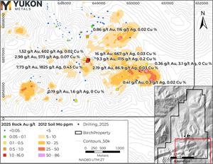
- Prospecting 2km south of the drill pad returned up to 16g/t Au, 1,825 g/t Ag, and 0.43% Cu, in surface rock samples from an area coincident with a large molybdenum soil geochemical anomaly (Figure 6).
“Our team is very encouraged by results from the first of six drill holes at Birch,” said Rory Quinn, President & CEO. “We are seeing clear evidence of a copper-gold skarn system, with high-grade zones and strong alteration along intrusive contacts. Early signs of a porphyry-style source are compelling, and we are particularly eager to see what emerges from Holes 3 and 4, spaced 750 meters apart within the 1400-meter-long skarn trend, with Hole 4 located within a surface high-grade gold anomaly.”
Drill Results
The 2025 drill program at Birch consisted of 1,685m of HQ diamond drill core in six holes off 4 pads (Figure 1). Highlights from Hole BR25-001:
-
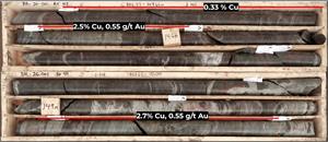
21.2m of 0.30% Cu (0.41% CuEq*) from 138.8m to 160m including 2.5% Cu with 0.55 g/t Au and 18.5 g/t Ag (3.2% CuEq) from 145.45–146.00m and 2.7% Cu with 0.55 g/t Au and 24.1 g/t Ag over 1.0m (3.5% CuEq) from 150.0–151.0m (Figure 2).

Figure 1 – 2025 Drill Location Map with Overlain 2024 Soil Copper Anomaly.
-
BR25-001 intersected several copper and gold bearing skarn horizons hosted in schist units adjacent to intrusive contacts. These high-grade zones occur within foliated skarn units containing disseminated and banded sulfides.
Table 1: Highlighted Drill Hole Assay Intervals
| Hole ID | From_m | To_m | Length_m | Cu % | Au g/t | Ag g/t | CuEq_%* |
| BR25-001 | 138.8 | 160.0 | 21.2 | 0.30 | 0.08 | 3.81 | 0.41 |
| and incl | 145.5 | 146.0 | 0.6 | 2.50 | 0.55 | 18.5 | 3.20 |
| incl | 150.0 | 160.0 | 10.0 | 0.39 | 0.10 | 5.76 | 0.53 |
| and incl | 150.0 | 151.0 | 1.0 | 2.70 | 0.55 | 24.1 | 3.45 |
| and | 283.0 | 283.9 | 0.9 | 0.00 | 1.50 | 0.25 | 1.43 |
| and | 285.4 | 286.0 | 0.6 | 0.45 | 0.45 | 5.20 | 0.93 |
Notes: True widths are not yet known but are estimated to be near true thickness based on current geological interpretation.*Copper equivalent (CuEq %) values have been calculated using the formula: CuEq % = Cu % + (Au g/t × 0.95) + (Ag g/t x 0.0095), based on metal prices of US $4.00/lb Cu, $3,000/oz Au, US $40/oz Ag. Recovery factors of 92% copper, 80% gold, and 60% silver were assumed based on a review of similar projects. No metallurgical test work has yet been completed at Birch.
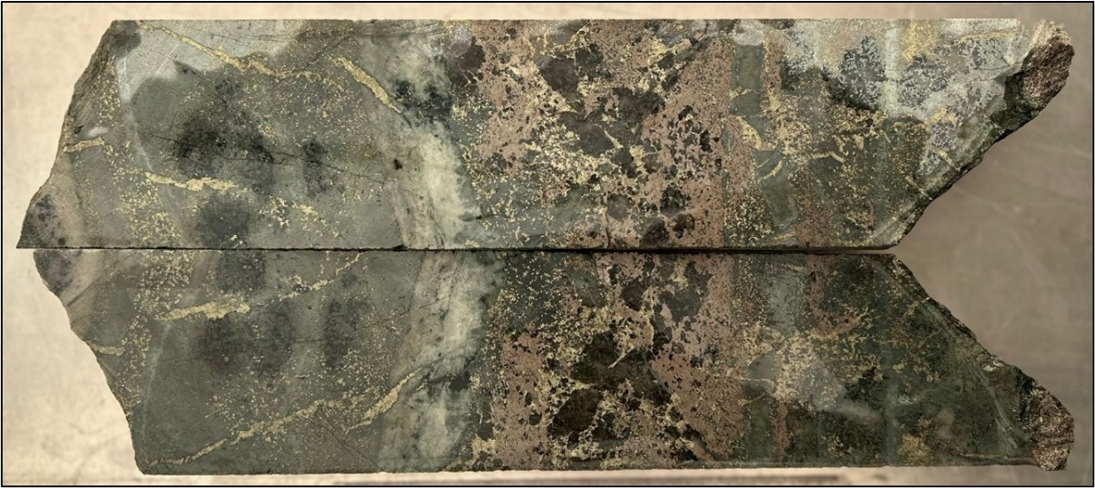
Figure 2 – Hole BR25-001 at 149m: close-up of massive pyrrhotite > chalcopyrite within skarn horizon grading 2.7% Cu, 0.55% Au, and 24.1 g/t Ag.
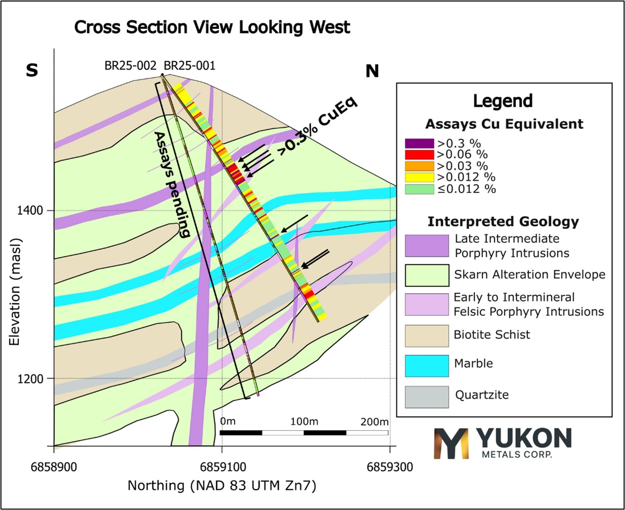
Figure 3 – Cross Section View of Hole BR25-001 with Copper Equivalent and Geologic Interpretation.
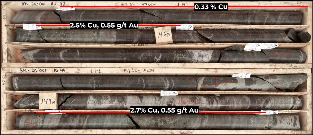
Figure 4 – Hole BR25-001 from 144m. Massive pyrrhotite > chalcopyrite zones within skarn horizons hosting up to 2.7% Cu and 0.55 g/t Au.
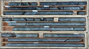
In addition, BR25-001 contained a particularly interesting section at around 311m depth, consisting of a crowded porphyritic intrusion with pervasive silica alteration (Figure 6). The interval hosts minor disseminated sulphides that returned geochemically anomalous copper values ranging from 350 to 575 ppm. Early interpretations suggest the unit dips south and may be related to subcropping mineralized dykes mapped approximately 2 km to the south and identified during the 2025 prospecting program.
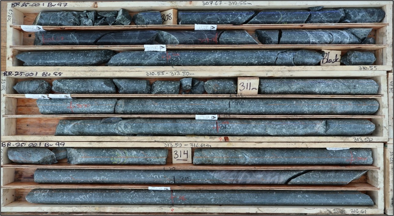
Figure 5 – Hole BR25-001 around 311m. Crowded porphyritic intrusion unit with minor disseminated sulphides and anomalous copper values.
Prospecting Results South of Birch Drill Area
Prospecting 2km south of the drill pad returned up to 16g/t Au, 1,825 g/t Ag, and 0.43% Cu, in surface rock samples from an area coincident with a large molybdenum soil geochemical anomaly.
A total of 133 rock samples were collected across the Birch property during the 2025 program, including 43 samples from an area located approximately 2 km south of the drilling area (Figure 4). This southern target, first identified by a molybdenum-in-soil anomaly in a 2012 grid and partially confirmed by Yukon Metals’ 2024 soils (News Release, October 16, 2024), is underlain by a potassium/thorium low in airborne geophysical surveys and has limited bedrock exposure. Sampling focused on float and subcrop boulders, which are considered near-source given the absence of glacial till overburden and low downslope transport of frost-heaved blocks.
Of the 43 samples collected in this region, 13 returned anomalous values in one or more of Au, Ag, Cu, Mo, Pb, W, or Zn (Table 2). Highlights from Birch Sampling Program:
-
16.0 g/t Au, 667 g/t Ag, 0.027% Cu, 81 ppm Mo, and 1.53% Pb from quartz-carbonate vein float with arsenopyrite, pyrite, and sulfosalts.
-
9.3 g/t Au, 1,115 g/t Ag, 0.20% Cu, and 5.96% Pb from a vein in subcrop with 10–15% sulfides, dominated by arsenopyrite and sulfosalts.
-
7.73 g/t Au, 1,825 g/t Ag, 0.43% Cu, and 1.58% Pb from vein float containing arsenopyrite, pyrite, galena, and sulfosalts.
-
2.98 g/t Au, 573 g/t Ag, 0.07% Cu, and 0.75% Pb from a quartz-epidote vein with arsenopyrite, chalcopyrite, and sulfosalts.
-
2,320 ppm Mo, 0.1% Cu, and 1% pyrrhotite from a skarn horizon developed in limestone subcrop.
The diversity of lithologies and mineral associations, including quartz-carbonate and quartz-epidote veining, altered diorite, schist, and skarn horizons, points to a broad hydrothermal footprint with multiple mineralizing pulses.
High silver and lead values correlate with sulfosalt and galena-rich samples, while molybdenum enrichment and associated copper in skarn float suggest proximity to a porphyry-style source. This southern anomalous area is interpreted as potentially linked to the mineralized skarn horizons intersected in the 2025 drilling, possibly marking a feeder zone or the outer expression of a buried porphyry system.
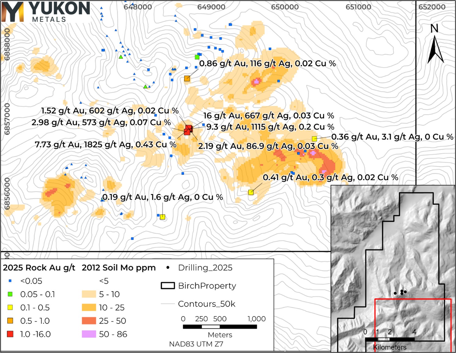
Figure 6 – Location of 2025 Rock Samples collected near the soil molybdenum anomaly on the southeast portion of the Birch property. 2024 Rock Samples are shown with triangle symbols.
Table 2 – Highlighted 2025 Rock Samples from Southeast Birch
| Sample | Au g/t | Ag g/t | Cu % | Mo ppm | Pb ppm | Sb ppm | W ppm | Zn ppm | Type | Lithology |
| K155346 | <0.05 | <0.5 | 0.02 | 5 | 1 | 3 | 470 | 69 | Float | Schist |
| K155352 | 16.00 | 667 | 0.03 | 81 | 15,300 | 3,800 | 5 | 189 | Float | Quartz Vein |
| K155353 | 9.30 | 1,115 | 0.20 | 1 | 59,600 | >10,000 | 5 | 3,470 | Subcrop | Quartz Vein |
| K155354 | 7.73 | 1,825 | 0.43 | 3 | 15,800 | >10,000 | 5 | 2,890 | Subcrop | Quartz Vein |
| K155355 | 2.19 | 87 | 0.03 | 20 | 6,070 | 255 | 5 | 81 | Subcrop | Quartz Vein |
| K155357 | 1.52 | 602 | 0.02 | 125 | 17,400 | 268 | 5 | 72 | Subcrop | Quartz Vein |
| K155362 | 0.36 | 3 | 0.00 | 17 | 150 | 7 | 5 | 42 | Float | Diorite |
| K155365 | 0.02 | <0.5 | 0.01 | 90 | 5 | 3 | 290 | 104 | Subcrop | Skarn |
| K155366 | 0.01 | <0.5 | 0.00 | 2,320 | 6 | 5 | 160 | 69 | Subcrop | Skarn |
| K155367 | 0.41 | <0.5 | 0.02 | 13 | 13 | 3 | 570 | 27 | Subcrop | Diorite |
| K155370 | 0.19 | 2 | 0.00 | 2 | 122 | 3 | 5 | 4 | Float | Schist |
| K155371 | 2.98 | 573 | 0.07 | 49 | 7,480 | 133 | 5 | 839 | Float | Quartz Vein |
| K155372 | 0.86 | 116 | 0.02 | 6 | 15,950 | 68 | 10 | 620 | Float | Schist |
Table 3 - 2025 Birch Drill Hole Locations
| Hole ID | Easting | Northing | Elevation | Total Depth (m) | Core Size |
| BR25-001 | 648314 | 6859029 | 1562 | 350 | HQ |
| BR25-002 | 648314 | 6859029 | 1562 | 401 | HQ |
| BR25-003 | 648587 | 6859167 | 1478 | 339 | HQ |
| BR25-004 | 647780 | 6859057 | 1550 | 285 | HQ |
| BR25-005* | 648317 | 6859295 | 1437 | 36 | HQ |
| BR25-006 | 648317 | 6859295 | 1437 | 273 | HQ |
*BR25-005 was ended early and redrilled due to poor ground conditions.
About the Birch Project
Yukon Metals owns 100% of the helicopter-accessed Birch project located 65 kilometres northeast of the community of Burwash Landing. The Birch project area is dominated by frost-heaved boulders in unglaciated terrain, with outcrop present on steeper ridges. The project lies predominantly within the Finlayson assemblage of the Yukon-Tanana Terrane, consisting of variably carbonaceous schist and quartzite, marble, garnet amphibolite and rare metaplutonic rocks.
The Yukon-Tanana Terrane structurally overlies the Ruby Range Batholith which is regionally mapped in the northeastern portion of the property occurring as Ruby Range quartz-feldspar porphyry and Rhyolite Creek porphyry and intermediate and felsic volcanic rock (Israel et. Al., 2011).
Project-level mapping indicates the geology of the area is comprised of schists and marble units, moderately to strongly oxidised felsic intrusive, and patchy oxidised porphyritic rhyolite dykes.
Yukon-based and Local First Nation Contractors Engaged
Drill pad construction at the Birch Property was completed by Minconsult in partnership with Vision Quest Drilling, a Kluane First Nation citizen-owned company. Helicopter support is being provided by Yukon-based Capital Helicopters. Drilling services were contracted to New Age Drilling in partnership with Vision Quest Drilling. Camp services were delivered by Käganì, a Kluane First Nation citizen-owned enterprise, in partnership with long-standing Yukon-based exploration contractor Archer Cathro.
QAQC
All diamond drill core from the 2025 program at the Birch Project was logged, photographed, and sawn in half using a diamond blade core saw. One half of the core was submitted for geochemical analysis, while the other half was retained in secure storage for reference. Sampling intervals were determined based on geological boundaries and typically ranged 0.3- 1.5 meters. Control samples comprised approximately 10% of all samples submitted, including certified reference standards, analytical blanks, field duplicates, and preparation duplicates. QA/QC results were reviewed in real time, and all data have been verified as meeting acceptable thresholds for accuracy, precision, and contamination before inclusion in this release.
Drill core and rock samples were sent to ALS Minerals for analysis with sample preparation in Whitehorse, Yukon and analysis in North Vancouver, British Columbia. Samples were prepared by crush to 70% passing 2mm, 250g split pulverised better than 85% passing 75 microns (Prep-31A). Pulp samples were analysed for 34 elements by four acid digestion and ICP-AES (ME-ICP61). All samples were analyzed for gold by fire assay and AAS with a 50g nominal sample weight (Au-AA24). Samples over 10,000 g/t Cu were assayed by Ore grade Cu- Four Acid (Cu-OG62).
Rock samples taken while prospecting referenced in this release are selective in nature and collected to determine the presence or absence of mineralization and may not be representative of the mineralization hosted on the project.
Qualified Person
The technical content of this news release has been reviewed and approved by Helena Kuikka, P.Geo., VP Exploration for Yukon Metals and a Qualified Person (as defined by National Instrument 43-101).
About Yukon Metals Corp.
Yukon Metals is a well-financed exploration company with a 17-project portfolio covering more than 43,000 hectares. Built on over 30 years of Berdahl family prospecting, the same team behind Snowline Gold’s district-scale assets, YMC provides exposure to copper, gold, silver, and critical metals. While advancing high-priority drill targets at the Birch and AZ copper-gold systems and the Star River gold-silver project, the Company is also conducting generative exploration across its broader portfolio to develop the next pipeline of discovery opportunities. Guided by an experienced leadership team with technical, financial, and Yukon expertise, the Company is well positioned to unlock new mineral discoveries across the Yukon territory.
Yukon Metals is committed to fostering sustainable growth and prosperity within Yukon’s local communities, while also enhancing shareholder value. Rooted in a philosophy of inclusiveness and shared prosperity, the Company’s strategy offers both local community members and investors the opportunity to contribute to and benefit from its success.
The Yukon
The Yukon remains one of the world’s last underexplored mineral belts, offering exceptional discovery potential. The Territory is home to a highly skilled and conscientious local workforce, shaped by generations of exploration experience coupled with a deep respect for the land.
Recent major discoveries with local roots, such as Snowline Gold’s Rogue Project - Valley Discovery, highlight the Yukon’s potential to generate fresh district-scale mining opportunities.
ON BEHALF OF THE BOARD OF YUKON METALS CORP.
“Rory Quinn”
Rory Quinn, President & CEO
Email: roryquinn@yukonmetals.com
For additional information please contact:
Kaeli Gattens
Vice President, Investor Relations & Communications
Yukon Metals Corp.
Email: kaeligattens@yukonmetals.com
Phone: 236-466-9837
CAUTIONARY NOTE REGARDING FORWARD-LOOKING INFORMATION
This news release contains certain forward-looking information, including information about the metal association and geology of the prospect area at Birch pointing to the prospectivity for a gold-rich copper porphyry system, significant scale having been demonstrated by a soil anomaly over 1,400 metres long, the potential for economic grades of copper and gold based on grades taken from surface rock chips, the Yukon’s potential to generate fresh district-scale mining opportunities, and the Company’s future plans and intentions. Wherever possible, words such as “may”, “will”, “should”, “could”, “expect”, “plan”, “intend”, “anticipate”, “believe”, “estimate”, “predict” or “potential” or the negative or other variations of these words, or similar words or phrases, have been used to identify the forward-looking information. These statements reflect management’s current beliefs and are based on information currently available to management as at the date hereof.
Forward-looking information involves significant risks, uncertainties and assumptions. Many factors could cause actual results, performance or achievements to differ materially from those discussed or implied in the forward-looking information. Such factors include, among other things: risks and uncertainties relating to Chair Mountain and other properties not being prospective copper-rich, gold-rich or silver-rich geological systems; rock samples analysed not being representative of overall mineralization; the required assumptions of completed helicopter-supported mapping and sampling programs; not having significant scale and a lack of economic grade minerals; the Yukon not having the potential to generate fresh district-scale mining opportunities; and other risks and uncertainties. See the section entitled “Risk Factors” in the Company’s listing statement dated May 30, 2024, available under the Company’s profile on SEDAR+ at www.sedarplus.ca for additional risk factors. These factors should be considered carefully, and readers should not place undue reliance on the forward-looking information.
Although the forward-looking information contained in this news release is based upon what management believes to be reasonable assumptions, the Company cannot assure readers that actual results will be consistent with the forward-looking information. The forward-looking information is made as of the date of this news release, and the Company assumes no obligation to update or revise the information to reflect new events or circumstances, except as required by law.
REFERENCES
Israel, S., Murphy, D., Bennett, V., Mortensen, J. and Crowley, J., 2011. New insights into the geology and mineral potential of the Coast Belt in southwestern Yukon. In: Yukon Exploration and Geology 2010, K.E. MacFarlane, L.H. Weston and C. Relf (eds.), Yukon Geological Survey, p. 101-123.
Photos accompanying this announcement are available at
https://www.globenewswire.com/NewsRoom/AttachmentNg/8f9e2c7a-deeb-4b19-b005-c4fe2c33fc7e
https://www.globenewswire.com/NewsRoom/AttachmentNg/bdfba866-b0b0-45da-abc2-d51551a12aaa
https://www.globenewswire.com/NewsRoom/AttachmentNg/98d206b9-2a91-48e5-a889-484d87fd3740
https://www.globenewswire.com/NewsRoom/AttachmentNg/3ec2e2d3-8f8b-437f-823a-1b651adcbcc0
https://www.globenewswire.com/NewsRoom/AttachmentNg/eede5c52-ceb0-4f8b-8aec-7972d17222f5
https://www.globenewswire.com/NewsRoom/AttachmentNg/d1b99356-74eb-449d-be97-84f8b4e2857b

![]()
Figure 1
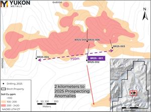
2025 Drill Location Map with Overlain 2024 Soil Copper Anomaly.
Figure 2
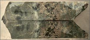
Hole BR25-001 at 149m: close-up of massive pyrrhotite > chalcopyrite within skarn horizon grading 2.7% Cu, 0.55% Au, and 24.1 g/t Ag.
Figure 3
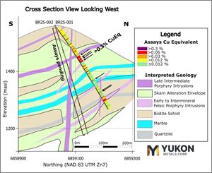
Cross Section View of Hole BR25-001 with Copper Equivalent and Geologic Interpretation.
Figure 4
Hole BR25-001 from 144m. Massive pyrrhotite > chalcopyrite zones within skarn horizons hosting up to 2.7% Cu and 0.55 g/t Au.
Figure 5
Hole BR25-001 around 311m. Crowded porphyritic intrusion unit with minor disseminated sulphides and anomalous copper values.
Figure 6
Location of 2025 Rock Samples collected near the soil molybdenum anomaly on the southeast portion of the Birch property. 2024 Rock Samples are shown with triangle symbols.
Legal Disclaimer:
EIN Presswire provides this news content "as is" without warranty of any kind. We do not accept any responsibility or liability for the accuracy, content, images, videos, licenses, completeness, legality, or reliability of the information contained in this article. If you have any complaints or copyright issues related to this article, kindly contact the author above.
